Data Products and Downloads: DNA13-P, -SV, -SH, SVjoint
P- and S-velocity models for the US integrating body- and surface-wave constraints
DOWNLOAD THE MODEL (zip file)
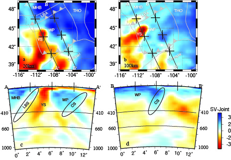
Maps and cross sections summarizing the Wyoming Province. Maps are centered on Wyoming. See Fig 6 Porritt et al 2014
Model highlights:
- The DNA13 model contains four estimates of the relative seismic wave-speed (1 P and 3 S) in the US upper mantle.
- The P, SH, and SV components utilize finite-frequency kernels and relative first arrival times for a set of body-wave only models.
- The SV-Joint component utilizes the SV component relative arrival times, teleseismically determined phase velocities, and ambient noise derived phase velocities in a single inversion.
- The Wyoming Province is imaged as thicker lithosphere than the surrounding continent, but with a low velocity zone due to the Yellowstone Plume. This thick lithosphere is coincident with the dipping high velocity body imaged by Yuan et al. with the CD-ROM array, but extends further eastward than the earlier experiment could resolve.
- The Llano province in central Texas is separated from the Laurentia Craton by the Southern Oklahoma Aulacogen which exhibits thin lithosphere under the basin. A high velocity body imaged under the Llano Province dips to the northeast and strikes along the Grenville Front suggesting it originated during the Grenville Orogeny at ~1.1Ga.
- The mantle structure through the transition zone displays markedly high velocity anomalies suggesting a tenuous subduction path for the Farallon slab.
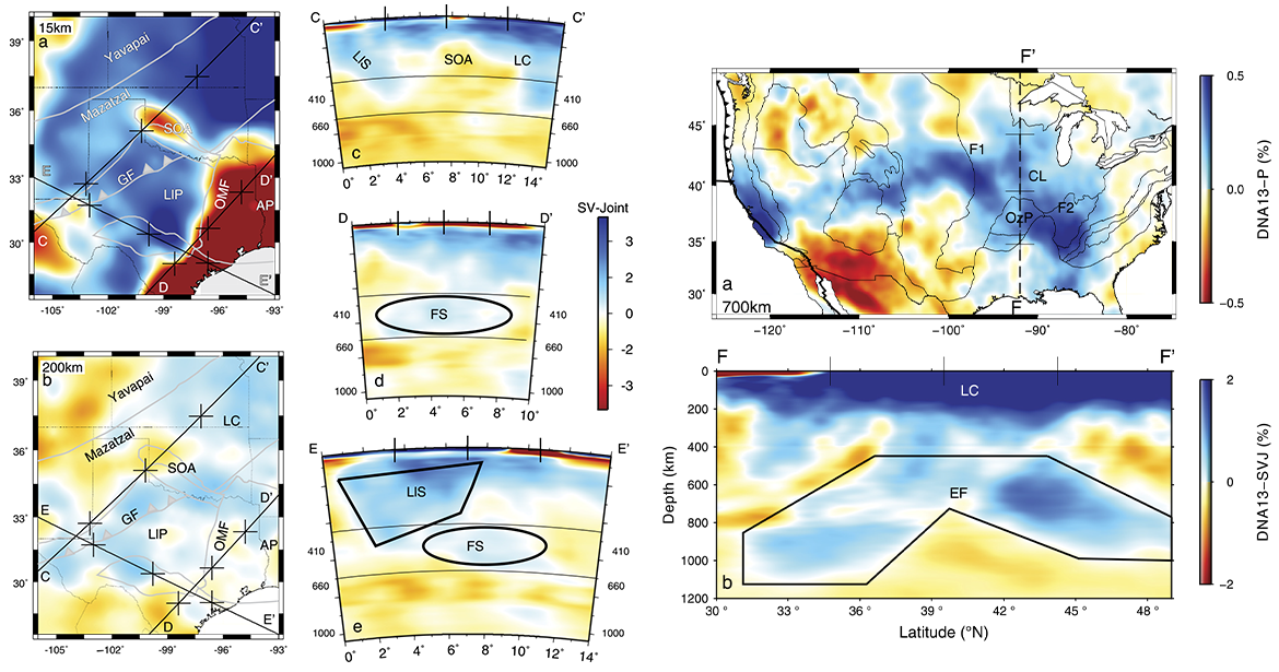
Left: Maps and cross-sections highlighting the Llano Provice. Maps are centered on Texas. See Fig 7. Right: Map and cross-section highlighting the deep slab under the eastern US. See Fig 8.
Model specifications:
- Parameters: DNA13 contains 4 estimates of relative wave-speed (P, SH, SV, and SV-J).
- Coverage: Good resolution extends from the Pacific coast to the Great Plains (~75 deg W), from the Mexican boarder (27 deg N) to the Canadian boarder (49 deg N).
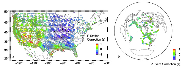
- Data source: More than 2200 stations where used from the USArray transportable array, regional seismic networks, and temporary seismic deployments.
- Data type: Relative traveltimes of teleseismic body waves (P and S) from over 350 earthquakes, surface wave phase velocity measurements over 167 eartqhuakes, and 5 years of ambient seismic noise drived phase velocities were used to constrain the model.
- Inversion: Finite frequency sensitivity kernels and phase velocity sensitivity kernels are used in a damped (but not smoothed) LSQR inversion.
- Resolution: The model can resolve mantle structure to a depth of ~1000 km and with a lateral and vertical resolution of ~250km. In the upper ~200km where the surface waves provide additional constraints the lateral resolution is ~100km and the vertical resolution is ~10km.